Preparations for Next Moonwalk Simulations Underway (and Underwater)
NASA conducts a hot fire of RS-25 engine No. 10001 on the Fred Haise Test Stand at NASA’s Stennis Space Center near Bay St. Louis, Mississippi, on Oct. 21, 2026.
NASA/Danny Nowlin
NASA conducts a hot fire of RS-25 engine No. 10001 on the Fred Haise Test Stand at NASA’s Stennis Space Center near Bay St. Louis, Mississippi, on Oct. 21, 2026.
NASA/Danny Nowlin
NASA conducts a hot fire of RS-25 engine No. 10001 on the Fred Haise Test Stand at NASA’s Stennis Space Center near Bay St. Louis, Mississippi, on Oct. 21, 2026.
NASA/Danny Nowlin
NASA tested RS-25 engine No. 10001 on Oct. 21 on the Fred Haise Test Stand at NASA’s Stennis Space Center near Bay St. Louis, Mississippi.
Test teams fired the developmental engine for almost eight-and-a-half minutes (500 seconds), the same amount of time RS-25 engines fire during launch of NASA’s SLS (Space Launch System) rocket.
During the test, operators also fired the engine up to the 111% power level, matching the thrust needed for new production engines to launch the SLS rocket and the Orion spacecraft to orbit.
The main objectives of the test were to acceptance test RS-25 flight components for future Artemis missions and validate the new thermal protection system, which protects the RS-25 engine nozzle from the thermal environment surrounding SLS during launch.
While this developmental engine will not be used in flight, the hot fire test provides NASA and NASA’s prime contractor L3Harris Technologies with the capability to capture critical data to improve engine performance and reliability.
Four RS-25 engines produce up to 2 million pounds of combined thrust to help launch the SLS rocket for each Artemis mission.
All RS-25 engines are tested and proven flightworthy at NASA Stennis prior to use. Tests are conducted by a team of operators from NASA, L3Harris, and Nova Space Solutions.
Preparations for Next Moonwalk Simulations Underway (and Underwater)
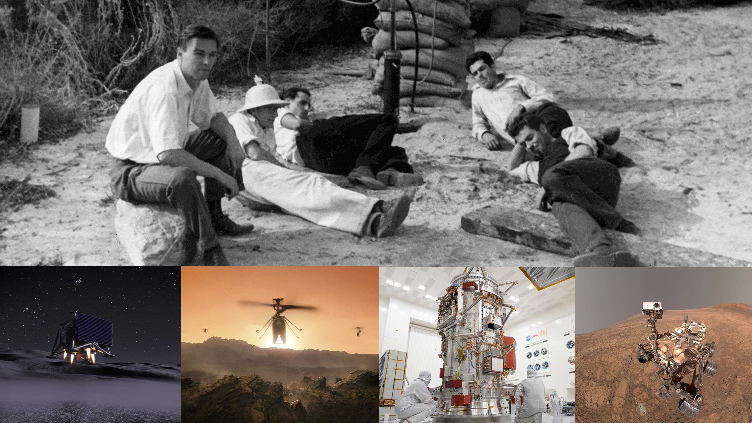
Clockwise from top: Caltech graduate students and friends carry out their first rocket firing on Halloween, 1936, in a dry riverbed along which JPL would rise. Their work helped make possible missions such as Perseverance and Europa Clipper as well as the future SkyFall and MoonFall missions.
NASA/JPL-Caltech
Interstellar probes. Lunar drones. Helicopters on Mars.
When a group of Caltech graduate students and enthusiasts began conducting rocket-propulsion tests in Pasadena’s Arroyo Seco on Oct. 31, 1936, they had no idea that their work marked the inception of the Jet Propulsion Laboratory. Ninety years later, the lab, now managed by Caltech for NASA, isn’t only celebrating the long line of historic firsts accomplished here; it’s paving the way for many to come.
Initially a contractor for the U.S. Army, JPL launched America’s first satellite, Explorer 1 in 1958. But rather than just orbiting Earth like the Soviet Union’s Sputnik, Explorer 1 became the first spacecraft to conduct science, thanks to an onboard Geiger counter that discovered the protective radiation belts encircling Earth.
The lab joined part of the newly formed NASA that same year. Within six years, in 1964, JPL sent the first U.S. mission to the Moon, Ranger 7. It also went on to lead the first planetary flyby, the first probe to visit all four gas giants, the first infrared telescope, the first rovers to roll on Mars, and the first rotorcraft to fly there, among many other historic milestones.
More firsts are on the way.
“Over the course of 90 years, JPL’s first-of-a-kind missions have transformed our understanding of the universe and our place in it,” said Dave Gallagher, JPL’s director since 2025. In 1992, only a couple years after he started as an engineer at the lab, Gallagher led the JPL team that built and tested the Wide-Field and Planetary 2 Camera for NASA’s Hubble Space Telescope, which delivered many of the mission’s most iconic images. “We stand on an extraordinary foundation, and we’re ready to push the boundaries with exciting new missions so that future generations can go even further.”
Aiming for a 2028 launch, the JPL-managed SkyFall mission will deploy three helicopters mid-descent over Mars to search to map hidden ice deposits and analyze weather patterns. Helping advance NASA’s Moon Base, JPL is developing MoonFall, a mission that will land a group of large propulsive drones at the lunar South Pole that same year. Set for a 2027 launch, SunRISE (Sun Radio Interferometer Space Experiment) features six toaster-oven-size satellites that will fly in formation to create a miles-wide radio antenna dish in order to study the Sun’s activity. What it reveals could help make space exploration safer for humans.
Protecting humanity is also the goal of the asteroid-hunting NEO Surveyor (Near-Earth Object Surveyor) mission, which, managed by JPL, will hunt for potentially hazardous space rocks that other telescopes can’t find. Once an object is spotted, NASA can offer a threat assessment and plan accordingly.
Closer to home, the same lab that launched the first oceanographic satellite in 1978 is at work on several missions that will offer a deeper reading of Earth’s vital signs. Where one mission will monitor the movement of water by measuring slight changes in gravity, another will study how powerful tropical convective storms form. A third will detail how different types of air pollution affect human health.
They add to a fleet of other Earth missions and projects JPL helps lead, including NISAR (NASA-ISRO Synthetic Aperture Radar) a joint mission with the Indian Space Research Organisation that can pinpoint how Earth’s surface changes in relation to natural disasters. Another, one of a series of instruments called AVIRIS (Airborne Visible Infrared Imaging Spectrometer), can even detect rare Earth elements critical to modern technology.
Flown on airplanes, the AVIRIS sensors were developed at JPL’s Microdevices Laboratory, which invented the “camera on a chip” technology that enables cellphones to take pictures. It’s also where the detectors are being developed for PRIMA (PRobe far-Infrared Mission for Astrophysics), a newly announced NASA mission that will strengthen humanity’s understanding of the universe by studying radiant energy visible only in the far-infrared.
“Bringing together the very best of scientific brilliance and engineering ingenuity from across Caltech and JPL continues to advance NASA’s priorities and empower America’s space leadership,” said Caltech’s president Ray Jayawardhana, who is also a professor of astronomy. “I can only imagine what those Caltech students experimenting with rockets in a little patch of dry riverbed would think if they could to see what Caltech and JPL have accomplished since, and where we’re headed next. Ninety years later, the same spirit of daring is still opening new frontiers and inspiring humanity.”
The 90th anniversary comes just a few weeks before another milestone, when on Nov. 18 Voyager 1 reaches a full light-day — the distance light will travel in 24 hours, which is some 16 billion miles, or 26 billion kilometers — from Earth. Ed Stone led the mission for 50 years, serving as JPL’s director for 10 of them. Stone died in 2024, but the Voyagers are continuing on their journey deeper into interstellar space, a place no other spacecraft have ventured. Turning 50 next year, they rely on NASA’s Deep Space Network (developed by JPL in the Apollo era) to receive commands and send back science data. Stone said that with both Voyagers exploring regions never before visited, “every day is a day of discovery.” The same could be said for JPL.
NASA’s Freedom 250 F-5 team, including NASA Administrator Jared Isaacman, performs a flyover during the national anthem at an NFL game between the Cleveland Browns and the Carolina Panthers at Huntington Bank Field, Sept. 27, 2026, in Cleveland.
NASA/Jordan Cochran
As part of the agency’s Inspiration Tour, NASA will conduct a flyover at the University of Alabama vs. Texas A&M football game in Tuscaloosa, Alabama, on Saturday, Oct. 24. NASA Administrator Jared Isaacman will pilot one of three F-5 fighter jets during the flyover, highlighting NASA’s contributions to aeronautics and the agency’s continued commitment to advancing aviation technologies.
Ahead of the game, members of the news media are invited to visit the NASA Experience Zone on Champions Lane, where Isaacman will participate in a media opportunity at 11 a.m. CDT. Media interested in attending should confirm their attendance by 12 p.m. Friday, Oct. 23, with Lance D. Davis at lance.d.davis@nasa.gov to receive additional details and instructions.
Supported by NASA’s Marshall Space Flight Center in Huntsville, Alabama, the NASA Experience Zone will be open to the public from 10:30 a.m. to 2:30 p.m. CDT, with no game ticket required. The experience will give visitors an opportunity to meet NASA team members and learn more about the people and technologies advancing the agency’s missions in aeronautics and space exploration.
Attendees can engage with NASA team members and explore exhibits highlighting the agency’s Artemis campaign and efforts to return astronauts to the Moon, including:
An inflatable SLS (Space Launch System) rocket.
Displays featuring the Starship and Blue Moon human landing systems.
Information about NASA internship opportunities.
Photo opportunities featuring NASA exhibits and displays.
With stops across the nation, NASA’s Inspiration Tour convenes academic, industry, and public sector stakeholders to connect the agency with the people, technologies, and organizations that drive American leadership in space.
The tour will culminate in MAX POWER, a public exposition of American air and space innovation, Saturday, Nov. 7, and Sunday, Nov. 8, on and near the agency’s Kennedy Space Center in Florida. Held in honor of America’s historic 250th anniversary, the multi-day, family-friendly event will showcase the next-generation aircraft, spacecraft, autonomous vehicles, and technologies that will help define the future of transportation in air and space.
For more information about MAX POWER and the agency’s missions, visit:
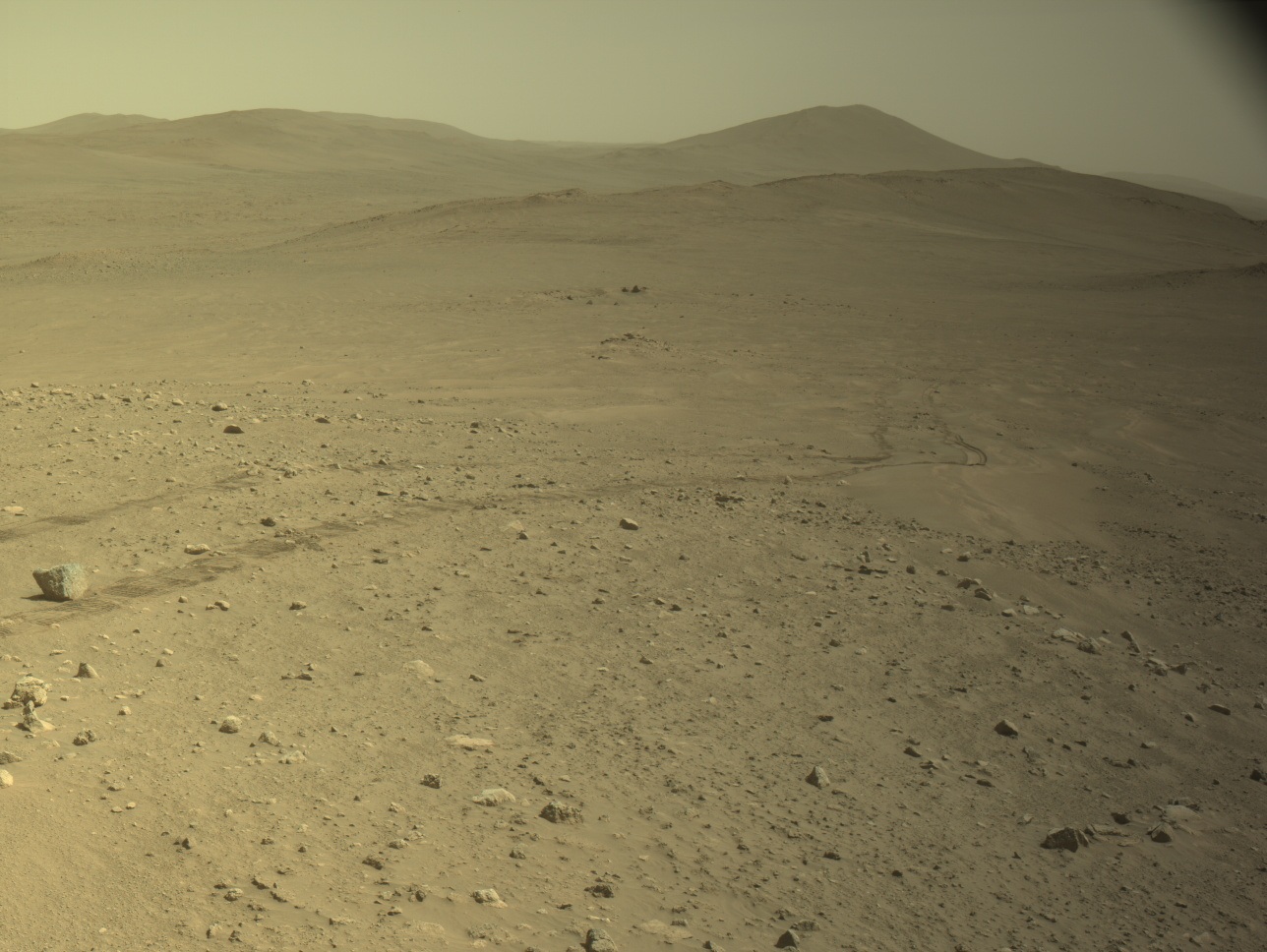
This image, taken by Perseverance on Mars, shows wheel tracks from the drive that broke the record for the farthest distance driven on another celestial body. The image was acquired with its Left Navigation Camera on Oct. 11, 2026 (Sol 2006) at a local mean solar time of 14:40:39.
NASA/JPL-Caltech
Written by Vandi Verma, Chief Engineer for Robotic Operations at NASA’s Jet Propulsion Laboratory
Oct. 12, 2026
Since the last blog update, Perseverance has achieved a major milestone on Mars. On Sol 2006 (Oct. 11, 2026), its odometer reached 45.22 kilometers (28.10 miles), setting a new record for the farthest distance driven on another celestial body. Its engineering twin here on Earth even received a plaque from Guinness World Records celebrating the achievement.
Two months ago, on Sol 1947, the odometer sat about 200 meters away from the milestone, a distance easily achievable with a single drive using Autonomous Navigation (AutoNav). However, the rover found itself in a very scientifically interesting area and spent time executing short drives to perform rock abrasions and proximity science on ancient rock outcrops. When Perseverance was finally ready to move on to a new site, it sailed past the record.
On its way to the drive record, Perseverance has navigated challenging terrain while also pioneering new ways to drive across the Martian surface. Perseverance’s various encounters with dense boulder fields and steep slopes have pushed the team to re-evaluate driving guidelines so the rover is better prepared to handle tough terrain. After running thousands of simulations, the team raised the rover’s tilt limit to 24 degrees and reduced the clearance required under the rover’s belly pan to 20 centimeters (about 7.9 inches). The team also updated the rover’s braking software to avoid rock hazards, nearly doubled steer motor current limits, updated flight software with “dynamic slip tables” to model expected slip, and used cross-slope driving to better anchor wheels on exposed bedrock.
One of the most exciting updates the team has made is an autonomous drive capability called onboard Global Localization (GBLC). GBLC repurposes the high-speed commercial processor inside the Ingenuity Helicopter Base Station to compare ground and orbital imagery to autonomously locate the rover in global coordinates at the end of a drive (as though we had GPS on a world without it), enabling Perseverance to drive longer distances without human intervention. Unlike Perseverance’s main flight computer, this coprocessor is not hardened against the punishing radiation environment of the Martian surface, where a thin atmosphere and the lack of a global magnetosphere leave little shielding. This radiation can induce “transient bit flips” in memory the software needs to function, and the team developed an effective software-based approach to radiation hardening. Looking forward to the greater demands of longer drives and to planning more activity with fewer resources, the team is also exploring the use of generative SI to help efficiently propose solutions to steer AutoNav along the many legs of a strategic path.
The team is using hard-won lessons from 45 kilometers (more than 28 miles) of driving to reinvent how the rover drives across the Martian surface. As Perseverance climbs higher along the crater rim, the next leap in autonomous exploration on Mars is just getting started.
Want to read more posts from the Perseverance team?
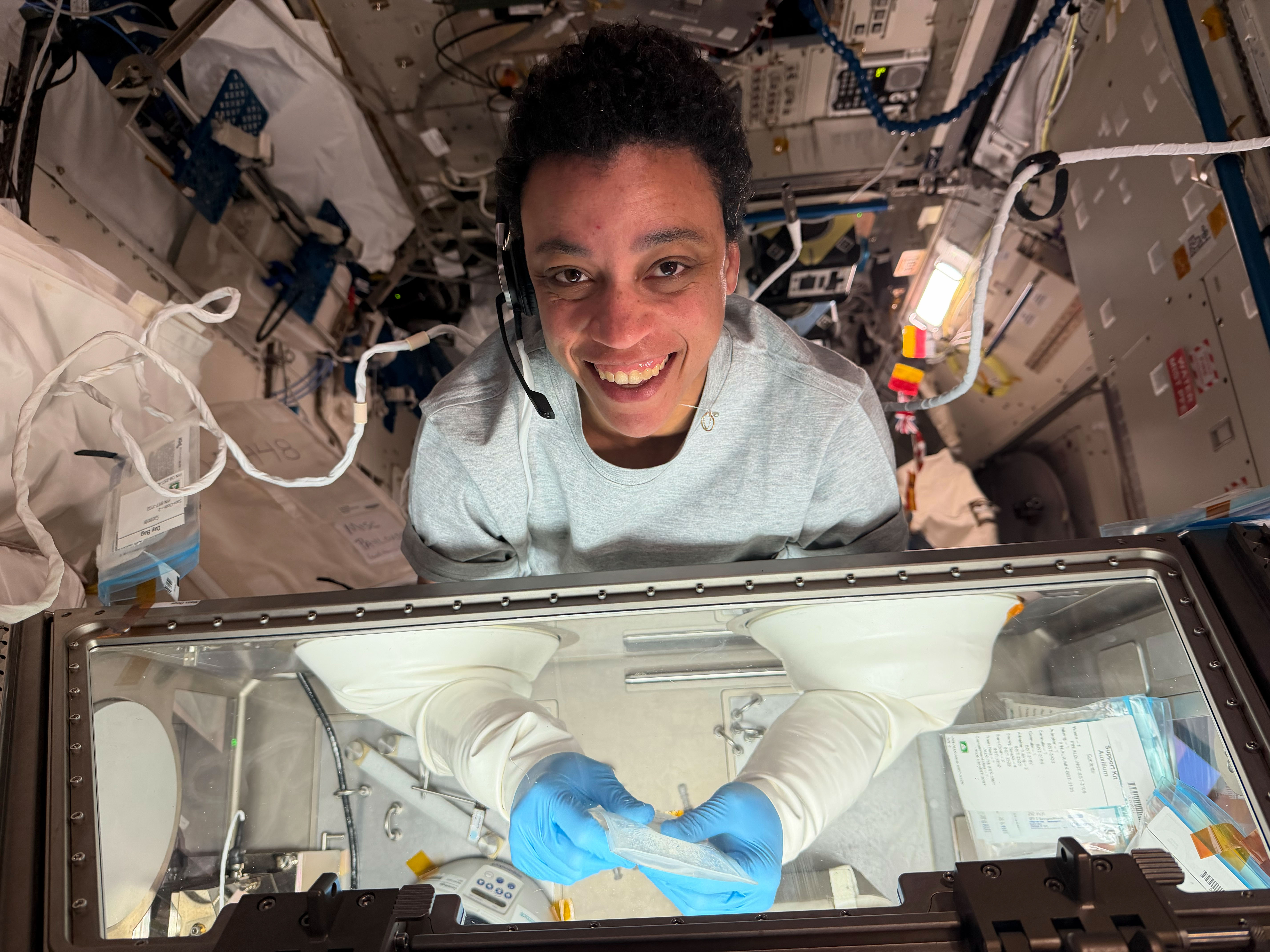
NASA astronaut and Expedition 75 flight engineer Jessica Watkins works inside the Kibo laboratory module’s Life Science Glovebox on Oct. 9, 2026, safely mixing living cell samples with a bioink and then filling a special cartridge with the cell‑ink mixture.
The advanced research operations were part of the InSPA‑Auxilium Bioprinter‑Cell Printing investigation, which explores 3D bioprinting cartilage tissue in microgravity of higher quality than that produced on Earth. Results may advance the ability to biomanufacture cartilage, benefiting patients on Earth and crew members on long‑duration space missions.
From orbit, today’s space-based laser instruments measure Earth’s forests and terrain one narrow line at a time. Between those lines are enormous gaps that include millions of acres of land scientists never directly measure. NASA’s CASALS instrument will blend machine learning with an ultra-compact lidar instrument to adaptively ‘sweep’ large swaths of Earth’s surface. This new capability for space-based remote sensors allows CASALS to create truly three-dimensional (3D) topographical renderings.
Video from a CASALS flight over the Great Cypress Swamp in Delaware on Nov. 12, 2024, showing tree canopy tops in green, the ground in purple, and near-ground vegetation in blue.
Credit: NASA
A team of researchers at NASA’s Goddard Space Flight Center (GSFC) has developed a new instrument designed to eliminate blind spots between lines of lidar data on the Earth’s surface. Built with support from NASA’s Earth Science Technology Office (ESTO), the Concurrent Artificially-intelligent Spectrometry Lidar System (CASALS) could help researchers map the features of Earth’s surface with unprecedented detail. Rather than mechanically steering a laser with moving mirrors, CASALS steers light using wavelength itself, generating a continuous, 3D swath of the ground below.
John Yorks, a physical research scientist at GSFC and Principal Investigator for CASALS, explained that the instrument features a novel transmitter and optical grating system that manipulates laser pulses without heavy, failure-prone motorized mirrors.
Instead, CASALS uses a fast-pulsing, tunable “seed” laser centered at 1040 nanometers, rapidly cycling through 256 unique wavelengths as it pulses through an optical component with a microscopic pattern of ridges called a transmission grating.
At this point, the physics of diffraction takes over. Because light bends at slightly different angles depending on its exact wavelength, the grating naturally “steers” each of the 256 pulses into a distinct position across the flight path.
This non-mechanical approach paints a continuous 3D swath of the ground. Not only does this eliminate the large unmapped gaps left between the isolated tracks of legacy spaceborne lidars, but stripping away moving parts drastically reduces the instrument’s size, weight, and power (SWaP) requirements. This makes it more reliable for the harsh environment of space.
Another key innovation within CASALS is its detector array. This component features a uniquely high Quantum Efficiency (QE), a variable that describes how effectively a detector converts incoming light (photons) into an electrical signal. CASALS operates at 80% QE. This means CASALS wastes almost none of the light that makes it back to the sensor.
With QE that high, CASALS can detect much weaker return signals, allowing it to collect useful measurements from darker surfaces or through denser vegetation.
This technology isn’t limited to a laboratory environment. In November 2024, an airborne CASALS prototype flew aboard NASA’s B200 King Air aircraft. The instrument produced science-quality datasets on its first campaign, exceeding the team’s expectations.
“I’m very impressed with Guang Yang, Jeffrey Chen, and all our engineers, and how well CASALS performed. This worked really well from the first time we flew it, which is pretty impressive,” said Yorks.
Flying at an altitude of roughly five kilometers, CASALS can distinguish individual tree branches and subtle changes in ground elevation, thanks to its 22-centimeter horizontal resolution.
“We’re able to see really fine details of vegetation structure and changes in the topography of the surface,” Yorks said.
But there’s more work to do to prepare the technology for space. The team plans to make several improvements to CASALS before creating a space-ready prototype. Specifically, they’re widening the instrument’s swath and adding onboard data processing software.
Transitioning from a successful airborne prototype to a fully realized space mission is a challenge, but the CASALS team is up to the task.
“The team’s really done a great job of sticking together and keeping on task and on schedule. We are being funded to optimize and improve the performance, and we’re also then looking at ways to take the technologies used in the airborne instrument and mature them and prepare them for a spaceborne version in the future,” said Yorks.
If successful, CASALS could become the first spaceborne lidar capable of mapping Earth’s forests and terrain as continuous three-dimensional swaths rather than isolated profiles, giving scientists a dramatically more complete picture of our changing planet.
For additional details, see the entry for this project on NASA TechPort.
Project Lead(s): John Yorks, NASA’s Goddard Space Flight Center
Sponsoring Organization(s): NASA’s Decadal Survey Incubation (DSI) program; NASA’s Instrument Incubation Program (IIP); NASA’s Goddard Space Flight Center; University of California, Santa Barbara; Virginia Polytechnic Institute and State University
Discover the cosmos! Each day a different image or photograph of our fascinating universe is featured, along with a brief explanation written by a professional astronomer.
New Ghosts Revealed in Cassiopeia
Explanation: Jinkies, look at all those ghosts! It took 100 hours of observation and a special oxygen filter for today’s image to capture three faint nebulas hidden in the Cassiopeia constellation. IC 59 and IC 63, the original Ghosts of Cassiopeia, haunt the region near multi-star system γ Cassiopeia. Energetic light from γ Cassiopeia causes the hydrogen gas in IC 59 and 63 to glow red. Their dust reflects and scatters some blue-ish white starlight. Newly discovered Objects 1, 2, and 3 appear as blue phantoms, revealing the presence of ionized oxygen. But ionized by what? Like at the bow of a speeding boat, γ Cassiopeia may be piling up material as the system moves through interstellar gas and dust. It follows that Object 3 may be the compressed and heated oxygen of that bow shock. Object 1 could be a planetary nebula if a central white dwarf is identified. The origins of these astronomical apparitions remain a mystery to be solved.
Read here for more information on how you can help the observing team behind today’s APOD.
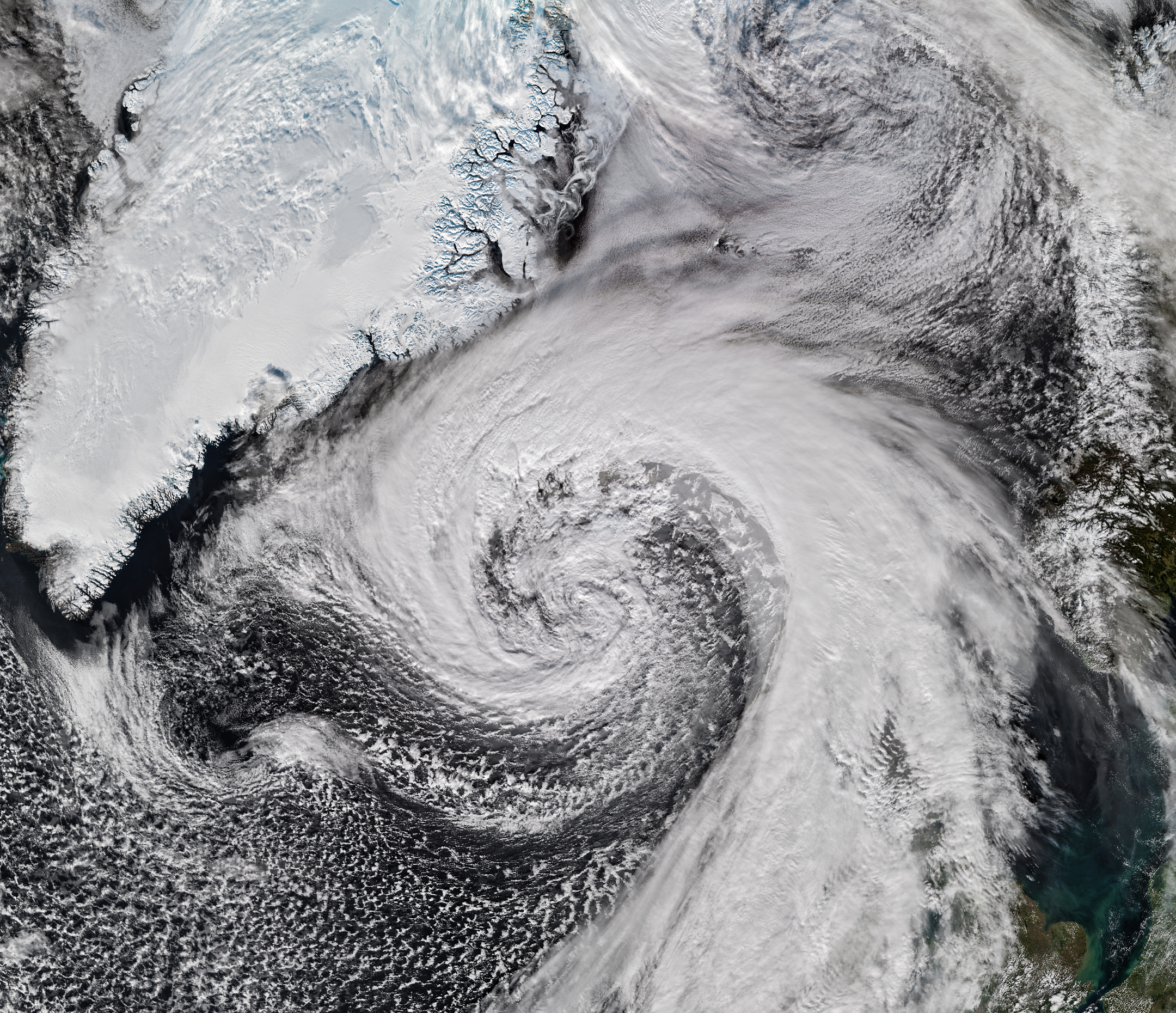
Hurricane Isaias—the only Atlantic hurricane to date in 2026—made landfall in Florida as a Category 2 storm on October 9. After delivering a rainy, windy blow to the U.S. Gulf Coast and drenching much of the Eastern Seaboard, the weather system had more in store.
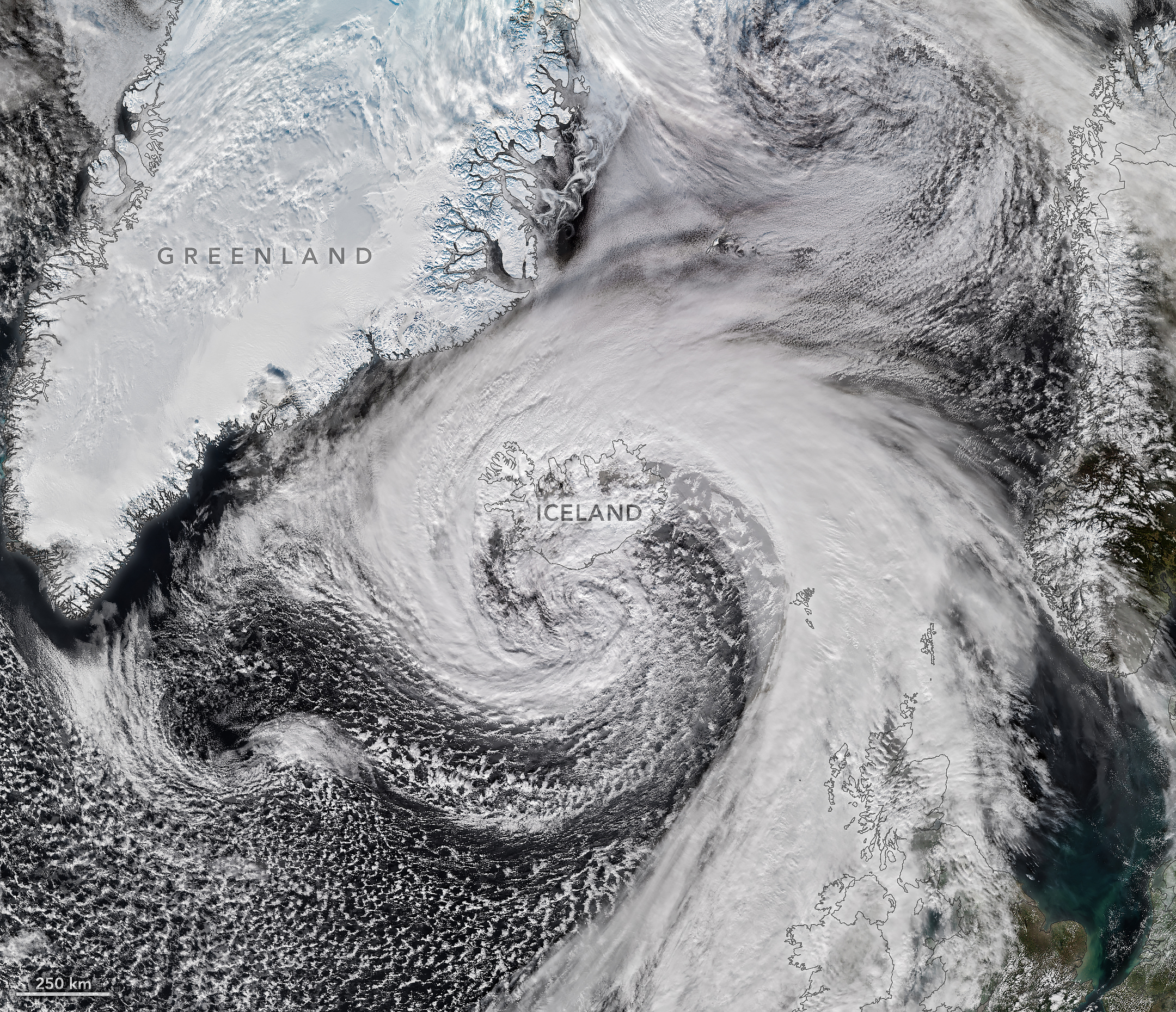
Riding the jet stream east over the North Atlantic, Isaias’s remnants developed into a powerful storm known as an extratropical cyclone. These low-pressure systems often feature asymmetrical, comma-shaped cloud patterns and can strike with hurricane-force winds, rain, and blizzard-like conditions.
The VIIRS (Visible Infrared Imaging Radiometer Suite) on the NOAA-21 satellite captured this image of the extratropical cyclone brushing past Iceland on the afternoon of October 14. During its journey, the system’s air pressure plummeted by more than 50 hectopascals over a 24-hour period, according to reports—approximately double the criteria for explosive cyclogenesis, or bombogenesis. Some meteorologists believe the storm may have set a new October low for barometric pressure in Iceland, after correcting for altitude, likely breaking a record that has stood since 1963.
The cyclone lashed Iceland with high winds as it grazed the coast. A gust of 205 kilometers (128 miles) per hour was recorded near Eyjafjallajökull volcano in the country’s south, while a small island just offshore saw sustained winds of 150 kilometers (93 miles) per hour. Damaging winds extended into northern parts of the country, where residents also braced for sleet and snow. Farther across the Atlantic, northwestern Scotland received gusts up to 90 kilometers (55 miles) per hour on October 14, according to news reports, resulting in cancellations on several ferry routes.
Editor’s Note: This article was originally published on Oct. 15, 2026, and has been updated to correct the location of the flights.
A NASA Dynamic Aviation A200 aircraft will conduct low-flying research flights over farmland near Amarillo, Texas, from Thursday, Oct. 22, through Monday, Nov. 9. These flights will measure gaseous and particulate emissions from animal feeding operations.
A photo of the Dynamic Aviation A200 aircraft, which will conduct low-flying research flights over farmland near Amarillo, Texas, to measure emissions in October and November 2026.
Dynamic Aviation
Agricultural emissions represent an important and understudied part of Earth’s land and atmosphere systems. The FarmFlux mission will deploy more than a dozen sensors to measure ozone, methane, ammonia, particulates, and other pollutants rising from crop lands and livestock farms and their interaction with the Earth’s atmosphere. The mission is jointly led by NASA’s Goddard Space Flight Center in Greenbelt, Maryland; Colorado State University; and Boston University.
Additional low-altitude research flights with a NASA P-3 Orion aircraft are scheduled for the March to July 2027 growing season in the Midwest and California’s Central Valley with a focus on cropland.
For more information about the FarmFlux mission, visit:
Preparations for Next Moonwalk Simulations Underway (and Underwater)
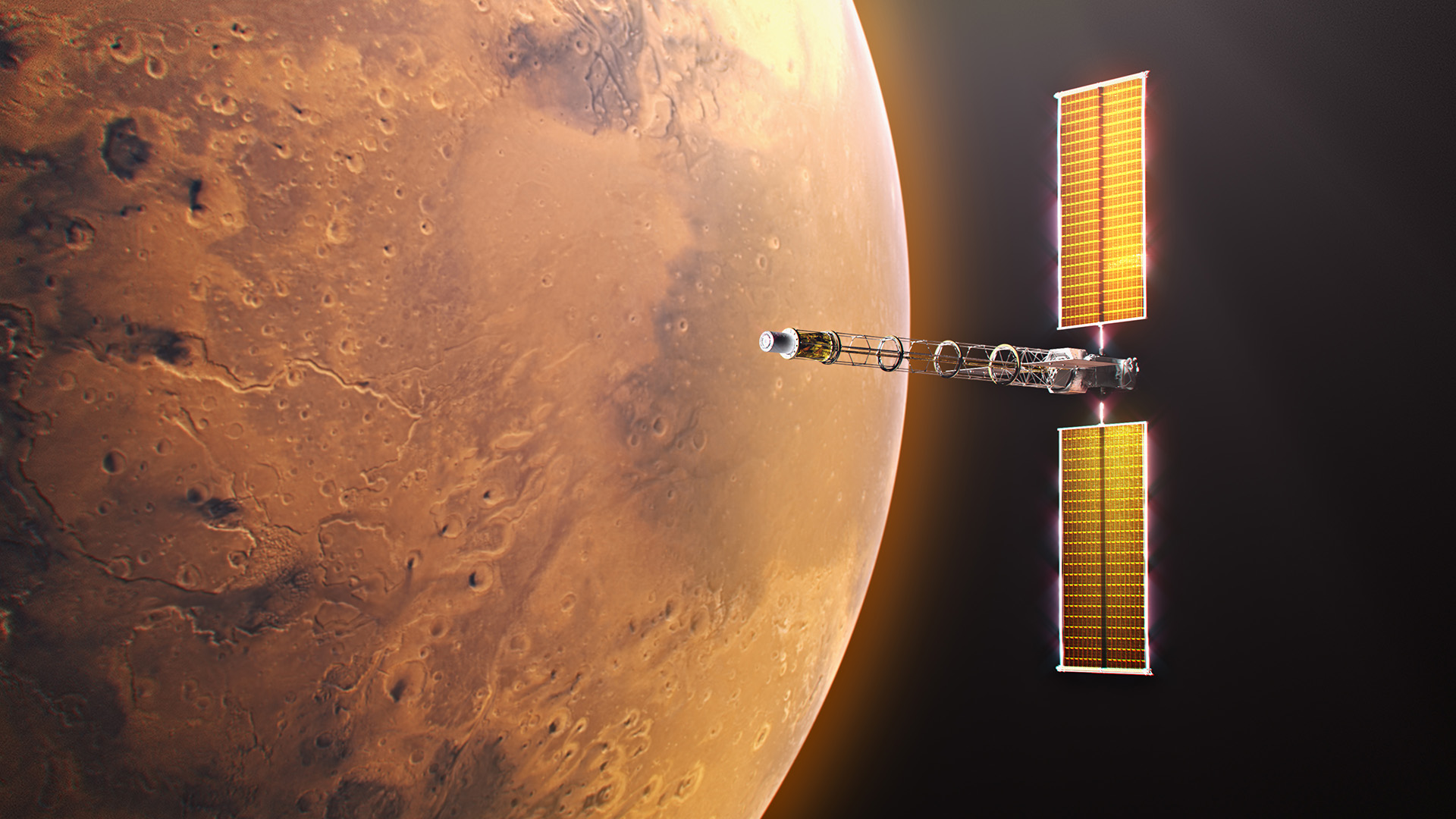
Space Reactor-1 Freedom will be the first spacecraft ever to demonstrate fission power beyond Earth’s orbit, traveling to Mars to deliver a science payload called SkyFall.
NASA/Alberto Bertolin
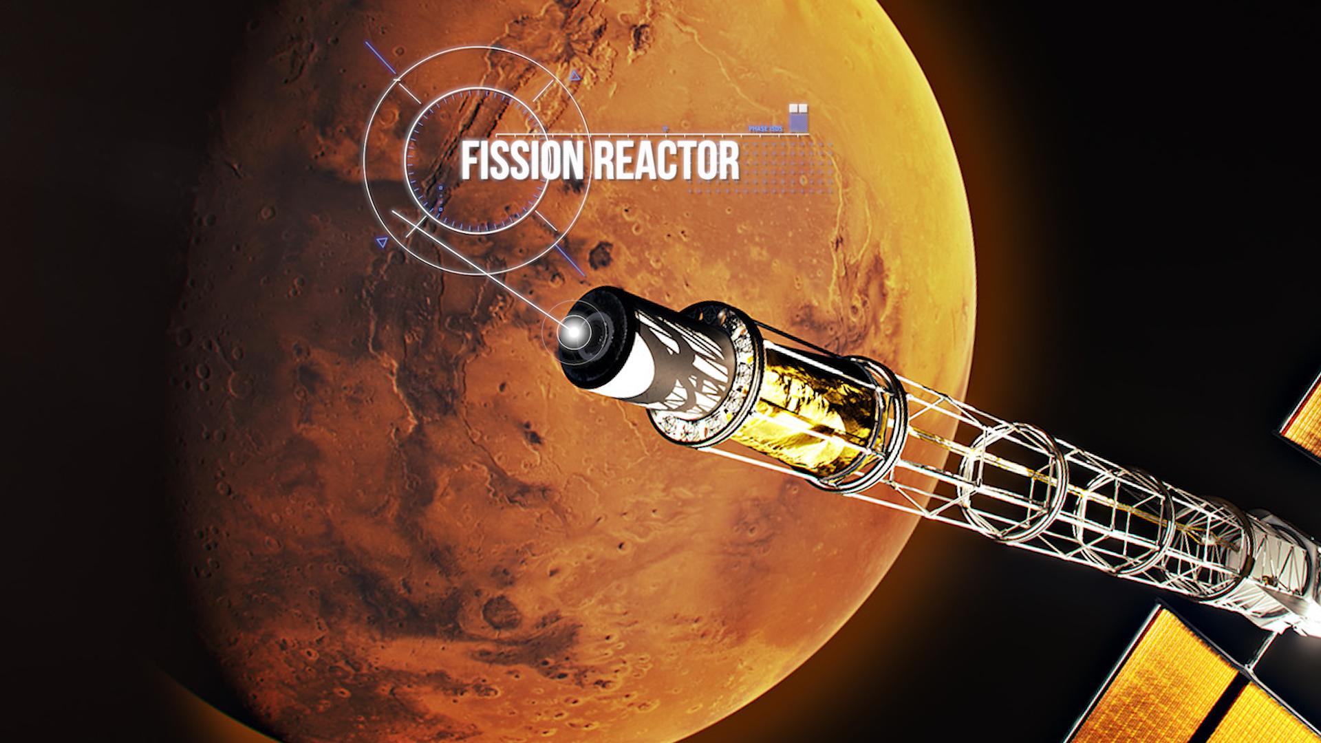
Destined for Mars and beyond, NASA’s Space Reactor-1 (SR-1) Freedom will be humanity’s first fission-powered spacecraft to travel outside Earth’s orbit. Announced during NASA’s “Ignition” event, this mission will demonstrate nuclear electric propulsion in deep space, and progress is underway on its key element: the nuclear power module. To expedite development of the spacecraft, NASA and its partners have mutually agreed to key contract actions that will advance the SR‑1 Freedom mission.
“These contract actions not only reduce technical risk and help us maintain momentum toward our 2028 launch, but they also strengthen collaboration across our partners,” said Steve Sinacore, SR-1 Freedom program director. “These actions keep SR‑1 Freedom on track and ensure we’re building the strongest possible foundation for NASA’s first fission‑powered voyage beyond Earth orbit while developing technology extensible to a vibrant space nuclear future.”
Space Reactor-1 Freedom’s nuclear power module, located at the end of the spacecraft’s boom, consists of a reactor that generates heat through nuclear fission and a power conversion system that converts that heat into electricity to power systems and electric propulsion.
NASA/Alberto Bertolin
Sierra Lobo Inc. will provide the nuclear power module’s closed Brayton cycle power conversion system, which converts thermal energy from its fission reactor into electrical power needed for SR-1 Freedom’s nuclear electric propulsion demonstration. The work will be conducted under the Space Flight Systems Development and Operations Contract III, awarded in 2024, to support spaceflight hardware design, development, testing, and operations at NASA’s Glenn Research Center in Cleveland.
The power conversion system will be integrated with the fission reactor, which is being designed and developed by the Department of Energy (DOE)’s Idaho National Laboratory to complete the nuclear power module. NASA and DOE incorporate thorough safety standards throughout the design and development of the SR-1 Freedom spacecraft, including interagency safety reviews, continuous oversight by a NASA chief safety officer, regulatory compliance, and a rigorous safety design process focusing on hazards, failure tolerance, and nuclear safety. In addition, the nuclear reactor portion of SR-1 Freedom will remain inactive until the spacecraft leaves Earth orbit.
Launching in late 2028, SR‑1 Freedom will deliver the SkyFall science mission, a team of three Mars helicopters evolved from the Ingenuity design, to collect scientific data, demonstrate exploration zones, and identify potential water sources. The mission will pave the way for deep space exploration and next‑generation fission-powered systems designed to keep NASA’s Moon Base operating through periods of darkness and in locations where solar power alone is not sufficient.
Discover the cosmos! Each day a different image or photograph of our fascinating universe is featured, along with a brief explanation written by a professional astronomer.
Ice Fishing for Cosmic Neutrinos
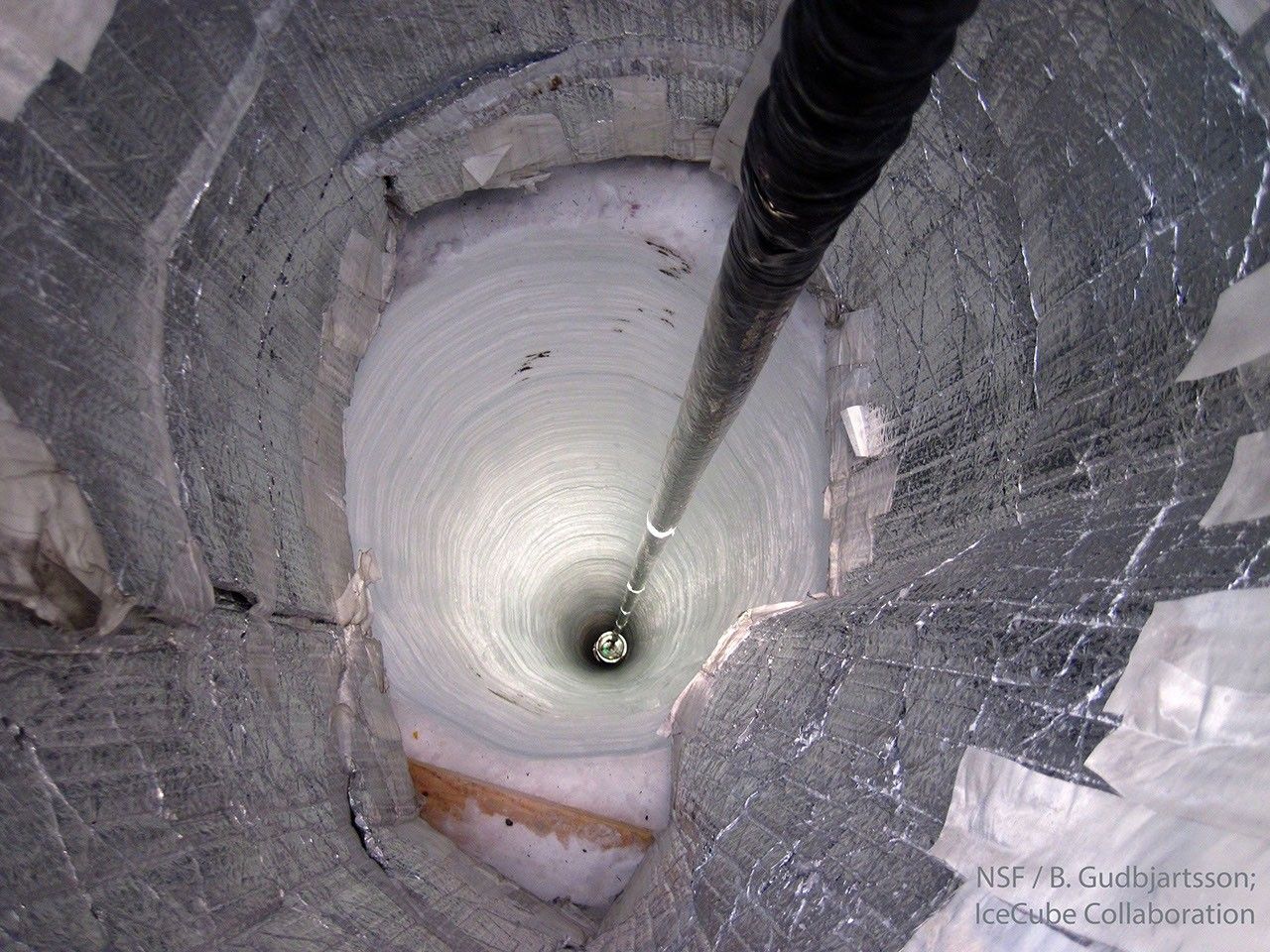
Explanation: Scientists are melting holes in the bottom of the world. In fact, almost 100 holes melted near the South Pole are now being used as an astronomical observatory. Astronomers with the IceCube Neutrino Observatory lowered a long string knotted with basketball-sized light detectors into each vertical lake. The water in each hole soon refreezes. The detectors attached to the strings are sensitive to blue light emitted in the surrounding clear ice. Such light results from fast-moving secondary particles liberated when high-energy neutrinos emitted by powerful processes out in the universe collide with ice molecules. IceCube has now detected many illuminating neutrinos. Pictured in 2010, one of the last of IceCube’s detector strings is lowered into the freezing abyss, making IceCube the largest neutrino detector ever created. In recognition of unprecedented discoveries, it was announced earlier this week that a founding leader of the IceCube Collaboration will be awarded the Nobel Prize in Physics.
NASA’s Freedom 250 F-5 team, including NASA Administrator Jared Isaacman, performs a flyover during the national anthem at an NFL game between the Cleveland Browns and the Carolina Panthers at Huntington Bank Field, Sept. 27, 2026, in Cleveland.
Credit: NASA/Jordan Cochran
As part of the agency’s Inspiration Tour flyover, NASA Administrator Jared Isaacman will pilot one of three F-5 fighter jets to kick off the New York Jets vs. Cleveland Browns game in East Rutherford, New Jersey, on Sunday, Oct. 11.
NASA team members will engage with fans at the agency’s Experience Zone, located at the Jets Tailgate Zone outside the stadium, from 10 a.m. to 1 p.m. EDT before the game. Fans can learn more about NASA’s return to the Moon under the agency’s Artemis dome, enjoy interactive games, and capture photos with a large, inflatable SLS (Space Launch System) rocket.
Isaacman will be available for limited media interviews during the game. To arrange interviews, please contact Camille Gallo at: camille.m.gallo@nasa.gov or 202-531-8057.
With stops across the nation, NASA’s Inspiration Tour convenes academic, industry, and public sector stakeholders to connect the agency with the people, technologies, and organizations that drive American leadership in space.
The tour will culminate in MAX POWER, a public exposition of American air and space innovation, Saturday, Nov. 7, and Sunday, Nov. 8, on and near the agency’s Kennedy Space Center in Florida. Held in honor of America’s historic 250th anniversary, the multi-day, family-friendly event will showcase the next-generation aircraft, spacecraft, autonomous vehicles, and technologies that will help define the future of transportation in air and space.
For more information about MAX POWER and the agency’s missions, visit:
Discover the cosmos! Each day a different image or photograph of our fascinating universe is featured, along with a brief explanation written by a professional astronomer.
Lunar Farside
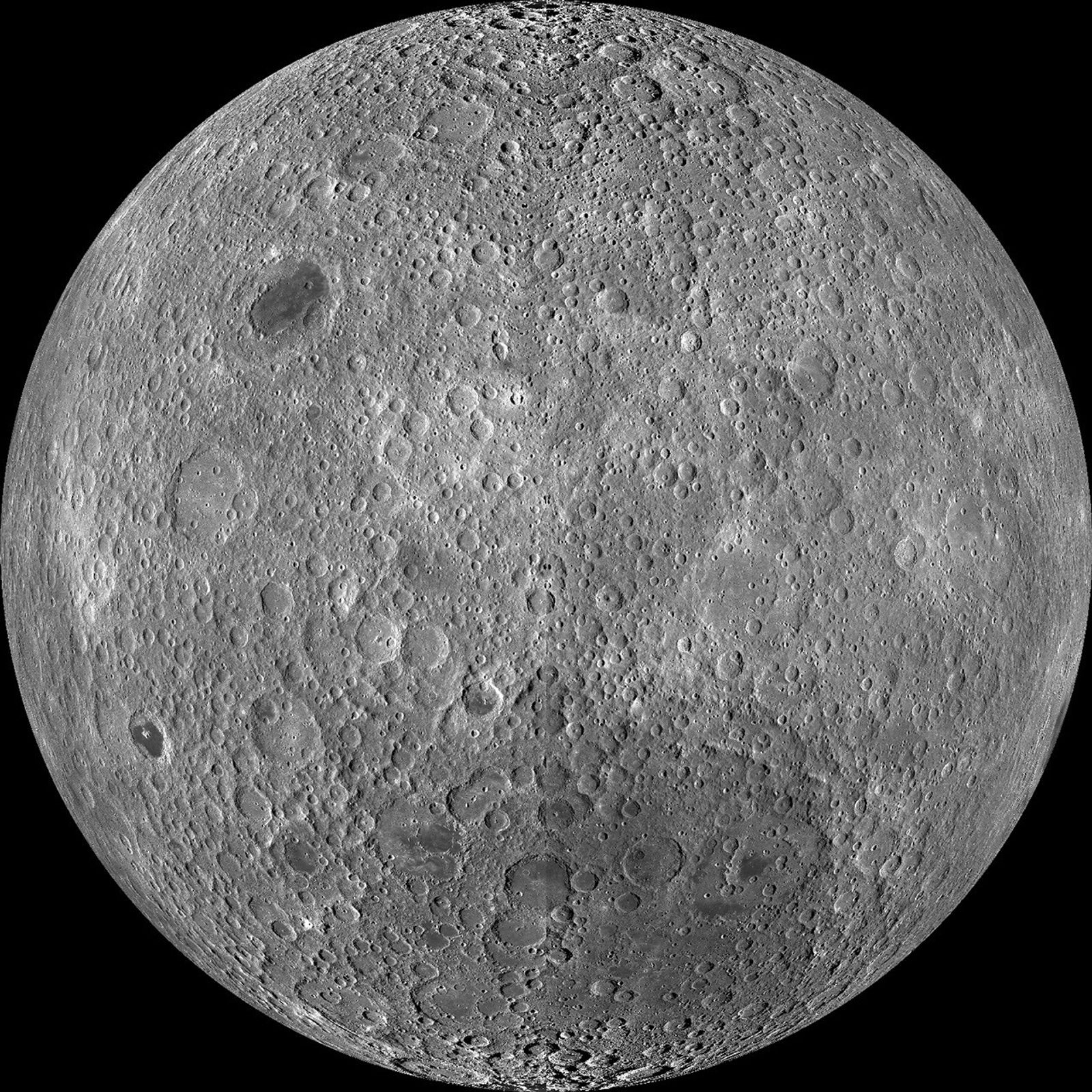
Explanation: Tidally locked in synchronous rotation, the Moon always presents its familiar nearside to denizens of planet Earth. From lunar orbit, the Moon’s farside can become familiar, though. In fact this sharp picture, a mosaic from the Lunar Reconnaissance Orbiter’s wide angle camera, is centered on the lunar farside. Part of a global mosaic of over 15,000 images acquired between November 2009 and February 2011, the highest resolution version shows features at a scale of 100 meters per pixel. Surprisingly, the rough and battered surface of the farside looks very different from the nearside covered with smooth dark lunar maria. A likely explanation is that the farside crust is thicker, making it harder for molten material from the interior to flow to the surface and form dark, smooth maria.
NASA is advancing American leadership in space by taking the next step toward a future where commercial space stations lead the way in low Earth orbit. On Friday, the agency released its final Request for Proposals inviting industry to submit plans for the next generation of commercial space stations.
“In alignment with the President’s National Space Policy, NASA is committed to maintaining a sustained American presence in low Earth orbit long after the International Space Station retires,” said NASA Administrator Jared Isaacman. “We will continue to need a place to conduct research, develop technologies, train crews, and prepare for missions to the Moon and Mars. Commercial space stations may provide that capability while creating new opportunities for American industry and allowing NASA to concentrate more of our resources on the near-impossible missions ahead.”
Building on the agency’s Ignition event earlier this year, NASA regularly has engaged with private industry to shape the agency’s future direction in low Earth orbit. This included publishing two Requests for Information in March to gather industry’s perspective on low Earth orbit destinations and transportation. The agency also published a draft Request for Proposals in July, followed by an industry day and one-on-one meetings that allowed interested companies to review and comment on the planned acquisition approach.
“We’ve made it clear that NASA will never give up its presence in low Earth orbit,” said Isaacman. “Since Ignition, we have spent a lot of time listening to industry and working through what it will take to make this transition successful. The opportunity is significant, but the economics ultimately have to work. We want to see credible plans, strong technical execution, and companies prepared to invest in destinations that can serve NASA while developing additional customers and markets of their own.”
Proposals are due Tuesday, Dec. 8, with contract awards expected in spring 2027.
Under the solicitation, NASA outlines requirements for companies interested in designing, building, testing, certifying, and operating commercial low Earth orbit destinations capable of providing end-to-end destination and transportation services for human spaceflight use.
NASA intends to award firm-fixed-price, multi-award, indefinite-delivery/indefinite-quantity contracts supporting development, certification, and services for continued low Earth orbit research and exploration. This will allow NASA to select two or more contractors through early development, followed by a competitive task order for final design, test, and evaluation, as well as certification and services from one or more contractors.
Learn more about NASA’s missions on the agency’s website:
Preparations for Next Moonwalk Simulations Underway (and Underwater)
A KREPE-3 capsule floats inside the Northrup Grumman Cygnus XL 24 cargo spacecraft on October 7. Inside the capsule is a 3-D printed heat shield designed by researchers at NASA’s Johnson Space Center in Houston.
NASA
NASA is testing heat shields that can keep astronauts safe as they return from missions to the Moon and Mars in an unusual way: by taking out the trash.
When Northrop Grumman 24th cargo resupply mission for NASA undocked from the International Space Station, it carried a fleet of 12 small, experimental capsules designed to test the next generation of thermal protection materials that could serve as the foundation for future heat shields.
The experiment, called the Kentucky Reentry Probe Experiment (KREPE-3), is the third in a series of low-cost, high-impact missions that use the final moments of the cargo spacecraft’s lifespan to gather valuable data.
The experiment is a collaboration among the University of Kentucky, the state of Kentucky, NASA’s Established Program to Stimulate Competitive Research (EPSCoR), several NASA centers, and other federal and commercial partners.
“KREPE-3 is a great example of the goals of NASA’s EPSCoR program,” said David Berger, EPSCoR program manager at NASA’s Headquarters in Washington. “We are supporting the next generation of scientists and engineers as they develop unique projects that benefit their education and NASA’s mission goals.”
Trash to treasure
Before the mission’s Cygnus XL spacecraft departed the station, astronauts packed it with waste and activated the 12 small capsules carried inside. Designed by University of Kentucky students, the capsules include sensors that will measure temperature, pressure, motion, magnetic field, and light during re-entry.
As the vehicle harmlessly breaks apart in Earth’s atmosphere on its planned route, the capsules will eject and begin collecting data on how each set of experimental heat shield materials performs. Satellite signals will transfer live data to researchers, offering insights into how larger heat shields could protect future cargo or crew.
“It’s a smart way to get flight data on materials that are still in development,” said Keith Peterson, a materials engineer at NASA’s Ames Research Center in California’s Silicon Valley. “We’re essentially hitching a ride on a vehicle that’s already coming back to Earth.”
Close up of an Ames-produced thermal protection system (TPS) (heat shield) for the Kentucky Re-Entry Probe Experiment (KREPE) in the Sensors & TPS Advanced Research Laboratories (STAR Labs) N242.
NASA/Brandon Torres-Navarrete
Heating up innovation
The capsules will carry a variety of thermal protective components, including proven technology such as the ceramic tile material used on the space shuttle. Others will test new options, such as a 3D-printed heat shield from the Additive Manufacturing of Thermal Protective Systems project developed at NASA Johnson and Oak Ridge National Laboratory.
Researchers at NASA Ames are contributing several materials to KREPE-3, including two capsules that will fly a next-generation family of protective coverings known as Materials Engineered for Re-entry using Innovative Needling Operations (MERINO). Made from layers of carbon and phenolic fibers stitched together like felt, the materials are more flexible, faster to produce, and less expensive than traditional protective substances – making them promising candidates for Mars missions. Thanks to Mars’ thinner atmosphere, missions to land on the Red Planet involve lower heat loads and allow for lighter protection.
A third capsule will combine those protective coverings with other elements. The Kentucky Instrumented Conical Hypersonic Experiment will utilize a dual-cone shape. It combines a tungsten tip attached to a cone layered with carbon and hear-resistant plastic fibers, and an aft cone wrapped in MERINO. This unique design will validate computer models against real-world data.
Another capsule is shaped like the protective aeroshell that will protect NASA’s upcoming mission, Dragonfly, as it arrives at Saturn’s moon, Titan, and will test the dynamic stability of the design. It is covered in Phenolic Impregnated Carbon Ablator, a material developed at NASA Ames that has applications for commercial vehicles and flew on NASA’s Stardust, Mars Science Laboratory, and Mars 2020 missions.
One capsule will test a deployable heat shield called Adaptable Deployable Entry and Placement Technology, which is shaped like an umbrella to increase surface area and slow descent. At full scale, Adaptable Deployable Entry design could be folded, making it ideal for deploying payloads that are larger than the rockets that launch them into flight.
While some capsules are testing new materials to carry missions to Mars, others are testing new shapes and designs that will further research and understanding of computer modeling and sensor design — technologies that could open doors to another generation of re-entry design innovation.
Additional capsules developed by domestic and international partners will test a variety of known and new materials, including a heat flux sensor developed at the University of Stuttgart in Germany, that will help researchers measure how heat moves across a surface during re-entry.
“We’re pushing the boundaries of what heat shields can do,” said Peterson. “And we’re testing them in a way that’s fast, affordable, and incredibly effective.”
Galaxies warp and multiply as if in a house of mirrors in this image from NASA’s James Webb Space Telescope released on Sept. 29, 2026.
The brilliant golden galaxies seen here are part of a galaxy cluster called MACS J0454.1-0300. The orange galaxies bunched together on one side of the image, however, are not actually part of the cluster, but rather galaxies much farther away whose light has been bent and magnified by gravitational lensing. This phenomenon occurs when the enormous mass of a foreground object such as a galaxy cluster bends and magnifies the light from a more distant object in the background.
Discover the cosmos! Each day a different image or photograph of our fascinating universe is featured, along with a brief explanation written by a professional astronomer.
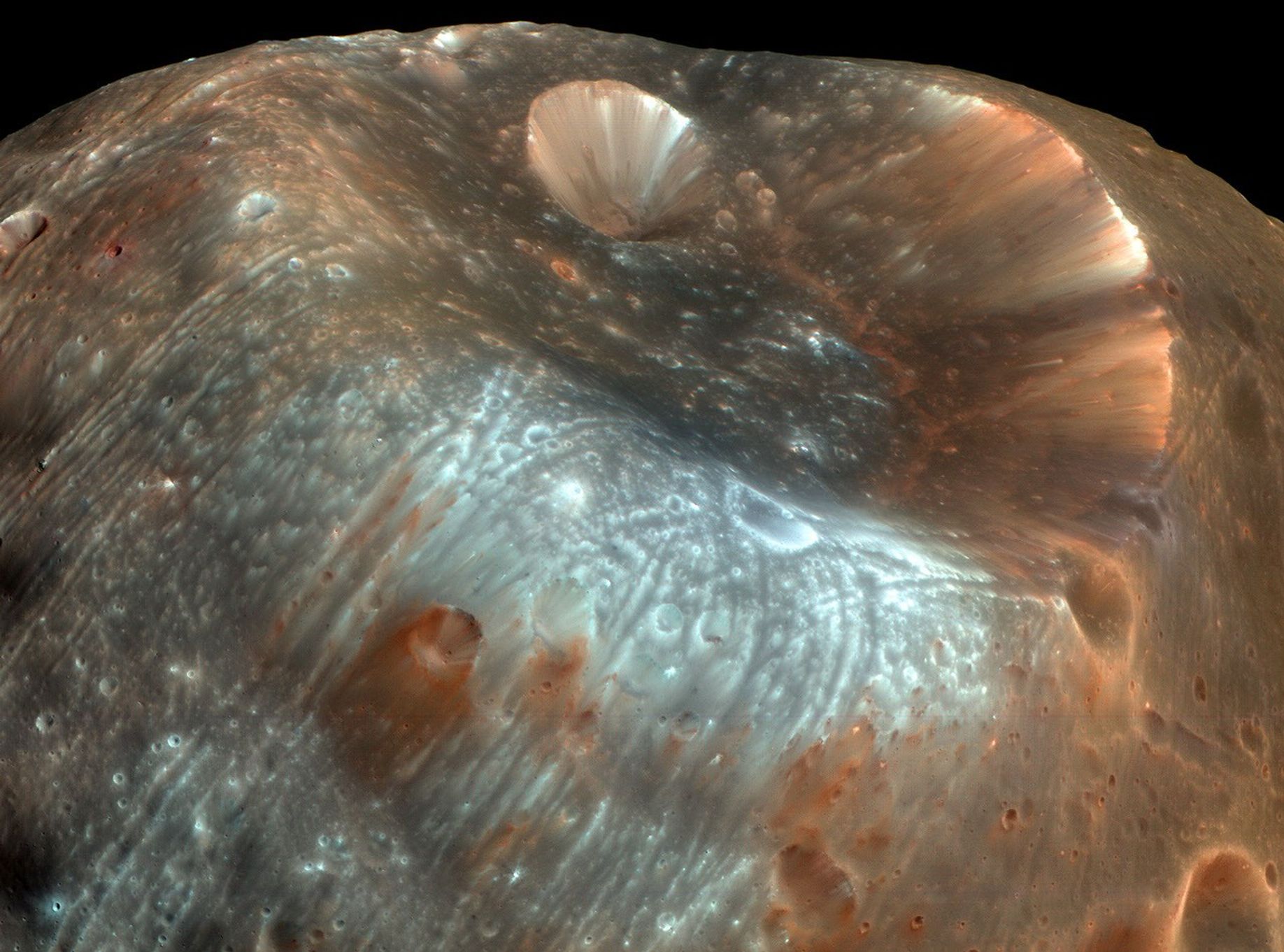
Stickney Crater
Explanation: Stickney Crater, the largest crater on the martian moon Phobos, is named for Chloe Angeline Stickney Hall, mathematician and wife of astronomer Asaph Hall. Asaph Hall discovered both the Red Planet’s moons in 1877. Over 9 kilometers across, Stickney is nearly half the diameter of Phobos itself, so large that the impact that blasted out the crater likely came close to shattering the tiny moon. This enhanced-color image of Stickney and surroundings was recorded by the HiRISE camera onboard the Mars Reconnaissance Orbiter as it passed within some six thousand kilometers of Phobos in March of 2008. Even though the surface gravity of asteroid-like Phobos is less than 1/1000th Earth’s gravity, streaks suggest loose material slid down inside the crater walls over time. Light bluish regions near the crater’s rim could indicate a relatively freshly exposed surface. The origin of the curious grooves along the surface is mysterious but may be related to tidal stresses experienced by close-orbiting Phobos or the crater-forming impact itself.
A narrow river (dark blue) meanders across vegetated land (bright green) in a false-color satellite image. Small geometric ponds or waterlogged fields appear on the left side of the scene.
NASA Earth Observatory / Lauren Dauphin
In a false-color satellite image of the same area, floodwaters (dark blue) flank a meandering river and cover a large swath of agricultural or aquacultural land primarily on the left side of the scene.
NASA Earth Observatory / Lauren Dauphin
October 7, 2025
October 2, 2026
September falls in the heart of the monsoon season in Thailand, where cities and towns are accustomed to the afternoon rains and thunderstorms that frequently roll through. But throughout late September and early October 2026, persistent heavy rains punctuated by intense downpours left low-lying areas across the country in Southeast Asia under sustained flooding.
Prachin Buri province was among the areas where flooding was widespread. The right image above shows land along the Bang Pakong River and nearby agricultural areas and aquaculture facilities inundated on October 2, 2026. The left image shows the same area at the same time of year in 2025. Acquired with NASA-USGS Landsat satellites, the images are false-color to better distinguish water from vegetation, developed land, and other surfaces. The bright red shapes are floating solar arrays.
Some of the flooding likely stemmed from a low-pressure system that stalled over the area for several days in late September. Stoked by moisture and energy from the warm Gulf of Thailand nearby, the system delivered especially intense rains to the region. About 100 kilometers (60 miles) to the west, Bangkok received nearly 300 millimeters (11.8 inches) of rain over a 48-hour period, according to news reports, close to the average monthly rainfall total for September of 344 millimeters (13.5 inches).
Since mid-September, flooding has occurred in 50 provinces across the country, affecting over 4 million people and causing dozens of deaths, according to the International Federation of Red Cross and Red Crescent Societies. Government agencies estimate about 270,000 hectares (670,000 acres) of farmland, including rice fields and fruit orchards, have been damaged.
NASA Earth Observatory images by Lauren Dauphin, using Landsat data from the U.S. Geological Survey. Story by Lindsey Doermann.
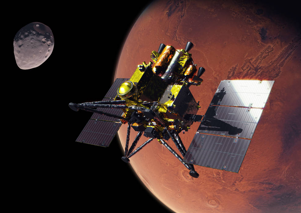
An artist’s concept of JAXA’s (Japan Aerospace Exploration Agency) Martian Moons eXploration (MMX) spacecraft at Mars.
Credit: JAXA
Media are invited to join NASA for a media teleconference at 4 p.m. EDT, Thursday, Oct. 15, to preview the agency’s contributions to JAXA’s (Japan Aerospace Exploration Agency) Martian Moons eXploration (MMX) mission. The mission is scheduled to launch from JAXA’s Tanegashima Space Center in Japan on Monday, Oct. 19 EDT (Tuesday, Oct. 20 JST).
Audio of the media teleconference will stream on the agency’s website at:
Participants in the briefing, who will provide an overview of the mission and NASA’s contributions, include:
Lindsay Hays, acting director, Planetary Science Division, NASA Headquarters in Washington
Tom Statler, MMX program executive and scientist, Planetary Science Division, NASA Headquarters
David Lawrence, MEGANE (Mars-moon Exploration with Gamma-rays and Neutrons) principal investigator, Johns Hopkins Applied Physics Laboratory
Kris Zacny, vice president, Blue Origin’s Honeybee Robotics
Media interested in participating by phone must RSVP no later than two hours prior to the start of the teleconference to Molly Wasser at molly.l.wasser@nasa.gov. A copy of NASA’s media accreditation policy is online.
The MMX spacecraft will arrive at Mars in August 2027 to begin its survey of the Red Planet’s two moons, Phobos and Deimos. After surveying Phobos in detail, the spacecraft will collect a sample of the moon’s surface no earlier than December 2028 and deliver it to Earth in 2031. NASA’s contributions to the mission include the MEGANE gamma-ray and neutron spectrometer, the spacecraft’s surface sampler mechanism, and communications and navigation support from the agency’s Deep Space Network, as well as funding United States scientists participating on the MMX science team.
The MEGANE instrument was developed by Johns Hopkins Applied Physics Laboratory. Honeybee Robotics, a Blue Origin company, developed the spacecraft’s pneumatic sampler mechanism. NASA’s contributions to the MMX mission were funded by the agency’s Discovery Program, which provides frequent flight opportunities for high-value, focused planetary science investigations. The Discovery Program is managed by NASA’s Marshall Space Flight Center in Huntsville, Alabama, for the agency’s Science Mission Directorate in Washington.
For more information about the MMX mission, visit:
Editor’s note: This release was updated Oct. 8, 2026 with the formal name of the summit.
NASA is launching two new science and technology initiatives to deepen scientific understanding and accelerate the innovation that will shape America’s future in space.
The initiatives are announced in conjunction with the White House Office of Science and Technology Policy’s (OSTP) “Science: A Golden Age Summit” in Washington on Thursday with top U.S. agency leaders. The programs reflect NASA’s commitment to pioneering research and transformative technologies and advancing the Trump Administration’s vision as outlined in the July report to the President, Science: A New Golden Age. One focuses on peer review and the other on fellowship researchers.
“NASA has a proud history of pursuing bold ideas and achieving the near impossible,” said NASA Administrator Jared Isaacman. “Under President Trump’s leadership, we are building on that legacy by creating new opportunities for great science, experimenting with how we evaluate and accelerate the best ideas, and investing in the next generation of researchers through the Genesis Mission Fellowships. We are entering a new Golden Age of American innovation and discovery, and NASA will be at the forefront.”
During a fireside chat, Isaacman and Michael Kratsios, assistant to the President for science and technology and director of OSTP, will discuss the following:
Establishing a coordinated metascience initiative within NASA’s Science Mission Directorate to strengthen the reliability, efficiency, transparency, and overall productivity of the agency’s scientific practices. As part of this effort, NASA is expanding the agency’s use of dual anonymous peer review to ensure proposals are evaluated solely on their intrinsic scientific merit. This approach enhances fairness and supports innovative and unconventional research ideas. Started as a pilot program during the first Trump Administration, this initiative has helped position NASA as a leader in advancing best practices in scientific review.
NASA will support 10 Genesis Mission Fellows, who are accelerated doctoral students with dual competencies in super intelligence (SI) and science or engineering. Fellows will work directly on NASA mission areas and conduct research at NASA laboratories, advancing SI-enabled scientific discovery. The fellowships will be based on NASA’s successful Future Investigators in NASA Earth and Space Science and Technology program.
NASA leads the nation in space exploration, scientific discovery, and technological innovation. Through these new initiatives, NASA will continue to inspire the world and drive progress in science and technology.

 Login